 (Host) Another series of heavy rainstorms caused widespread damage across Vermont over the past 24 hours.
Meteorologists say weather patterns over the Atlantic Ocean and along the jet stream have trapped the region in a vise grip of storms.
And, as VPR’s Ross Sneyd reports, the bad weather could continue for a while, yet.
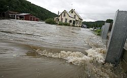
(Sneyd) Roads have washed out. Buildings flooded. Homes and camps have been evacuated.
This summer has not been one for those with a weak constitution. Especially in Addison County.
Dan Werner is operations director for the town of Middlebury.
(Werner) “It’s kind of been one after another. I know Middlebury and Ripton have gotten hit pretty hard this summer with the June storm and now this one. So it’s trying people’s patience a little bit.”
(Sneyd) Consider that in Ripton, a small mountain town just east of Middlebury, crews had just finished repairing some of the roads that washed out in June.
Much of that work has now washed down the hillside again.
Bruce Berryman, chairman of Lyndon State College’s meteorology department, says there’s a term for this.
(Berryman) “It’s been augmented by the fact that these storms are what’s called `training,’ meaning that a series, a line of storms will go down the same path, just like cars on a railroad track. So … when we have a thunderstorm, usually we might get one. But in this case we might get two or three over the course of six or eight hours as that whole line of storms go right over the top of any particular place.”
(Sneyd) Berryman has studied Vermont weather records. Over the past century, average temperatures have risen about one degree. And precipitation has risen over the past 25 years.
(Berryman) “I think the combination of having temperatures going up and precipitation going up and severe weather going up, many people look at that and see a relationship there. It’s unfortunately the kind of thing that would have to go on for a lot longer before somebody could do a statistical study and prove that one was causing the other. But it makes meteorological sense that with warmer temperatures you would also be getting more humidity in the atmosphere and with more humidity in the atmosphere you would also be getting more storminess.”
(Sneyd) Jay Shafer also teaches meteorology at Lyndon State.
He has a different term for why this weather has been so unrelenting.
(Shafer) “We’re seeing some persistent high ridging, a big area of high pressure in the north Atlantic and western Atlantic Ocean and that’s really slowing a lot of the movement of these deep low pressure systems coming from the West, tapping a lot of moisture. So we’re getting two, three big storm events. We usually get maybe one of these events a summer, and it’s really adding up to a lot of rainfall.”
(Sneyd) That area of high pressure over the ocean is caused by warm water temperatures at the surface of the Atlantic. A more southerly flow of the jet stream has kept the storms funneling into our region, where they stall when they hit the high pressure over the ocean.
Shafer says it could take time for those ocean water temperatures to fall. That means the rainy weather could extend into the fall.
For VPR News, I’m Ross Sneyd.